This post is also available in:
 Deutsch
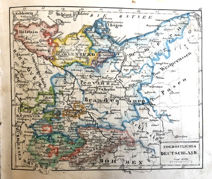
The map shown in the exhibition is of northeastern Germany. The borders of the different parts are clearly marked in this map. Other parts of the world were not as well known, explored or surveyed at that time. In the map of Africa, for example, the borders of the different countries are only indicated at the coastline, the interior regions of the continent are still mainly blank and marked as «unknown countries». The maps are, as stated on the title page, lithographs, but were still printed in just black and white. The colours were added afterwards by hand.

Duodez describes the smallest book format, in which a sheet of paper is folded into twelve sheets. Until the 19th century, paper formats were not standardized and sizes varied from one maker to another. It was not until 1883 that standardisation of paper size began in Germany. The DIN-format was introduced in the early 1920s.
A digital version of the 1833 edition of the atlas is available in the catalogue of the Austrian National Library. his exhibit and other atlases from the 18th and 19th centuries are shown in the exhibition «Exploring the world» on floor J of the Main Library – Science.
Eduard Beer: Kleiner Duodez-Atlas in 24 Blatt über alle Theile der Erde vornehmlich zum Gebrauch bei Cannabichs Schulgeographie, aber auch brauchbar bei allen übrigen Lehr- und Unterrichtsbüchern der Erdbeschreibung. Zweite verbesserte Auflage. Weimar, Voigt 1835