This post is also available in:
 Deutsch
The Winterthur born Swiss cartographer Jakob Melchior Ziegler (1801-1883) studied in Geneva under Guillaume Henri Dufour, the creator of the well-known Dufour map. In 1842, Ziegler, together with lithographer and cartographer Johann Ulrich Wurster (1814–1880), founded a very successful cartographic institution with publishing house in Winterthur. Ziegler produced numerous maps of excellent quality, including topographic maps of St. Gallen, Appenzell, Glarus and the Engadine, as well as several national maps of Switzerland. The Allgemeine Atlas über alle Teile der Erde in 29 Blättern was published in 1857 by Ziegler and Wurster. It is based on the work of Carl Ritter (1779-1859), one of the founders of modern geography.
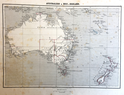
Shown in the exhibition is a map of Australia and New Zealand. The continent had been visited several times by Dutch seafarers since the 17th century, some of whom had also mapped parts of it. In 1770 James Cook reached the east coast, claiming a region which he called New South Wales. In 1788 the first British settlers arrived in the “convict colony Australia”. The map in Ziegler’s atlas still shows a majority of white areas. Of today’s states only New South Wales, South Australia and Victoria exist. Western Australia, covering the entire western third of Australia today, is only a small area in the southwest. In 1642, the Dutchman Abel Tasman set foot on the island south of Australia and named it Van Diemen’s Land, in honour of Antonio van Diemen, Governor General of Dutch India. In 1856 it was renamed Tasmania after Abel Tasman.
A digital version oft Ziegler’s map is available at e-rara.ch. This exhibit and other atlases from the 18th and 19th centuries are shown in the exhibition «Exploring the world» on floor J of the Main Library – Science.
Jakob Melchior Ziegler: Allgemeiner Atlas über alle Theile der Erde in 29 Blättern. Reduction des von J.M. Ziegler nach C. Ritter’s Lehre herausgegebenen Atlases in 24 Blättern. Winterthur, Wurster 1857