by Maitane Iturrate
Kytalyk, July 3, 2013
During this year’s first field campaign, my main objective of the field work is to characterize, in terms of biodiversity, the research area, including a floodplain, lowland tundra and a hillside. To reach this objective, measurement plots will be selected in these areas, the species composition is determined and important plant traits related to the radiation balance are measured in the tundra. These include leaf length, width and leaf optical properties, height and architecture of the different plants.

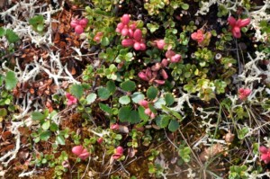
Mixed dry vegetation patch, including Betula nana, Vaccinium vitis idea, sedges, brown mosses (Photo: G. Schaepman-Strub, July 2010).
Simultaneously, soil measurements will be taken in order to analyze the correlation between abiotic traits (i.e. soil moisture, pH, Active Layer Thickness…) and the plant traits measured. In addition, other vegetation relevées will be selected and measured using the Braun-Blanquet approach. This approach will allow us to assess the phyto-sociology of the area (plant associations).

Preliminary species list of the Kytalyk area based on previous field campaigns. This year a botanist from St. Petersburg will join us to complete the local species list as a reference for expected future changes (Table: M. Iturrate, June 2013).
Most of the results obtained will be used for radiative transfer modeling. 3D objects for the DART model will be designed using results from the measured plant traits. The aim of the 3D object database is to create different scenarios of plant compositions and to study the behavior of the impact of short-wave radiation within them. The results obtained will be validated by removal experiments reproducing the scenarios created (but this will be another field campaign 🙂 ).
URPP GCB Project 1: Cross-scale quantification of vegetation–atmosphere interactions and biodiversity change
Gabriela Schaepman-Strub, Pascal Niklaus, Maitane Iturrate, Inge Juszak, and NN (position currently open)
We investigate biodiversity-effects on vegetation-climate interactions. For this, we combine process-based modelling and statistics to link terrestrial biodiversity measures, in-situ proxy observations of energy and carbon fluxes, and corresponding satellite-inferred landscape-scale products (albedo, vegetation biochemistry, canopy structure, evapotranspiration). The 3D radiative transfer model DART will be used to explore how species diversity influences albedo, canopy light distribution, and ground level radiation throughout the growing season. The parametrization of DART requires the definition of a limited number of plant functional groups through selected traits that are representative of the functional and taxonomic diversity of tundra vegetation, but at the same time adapted to the intermediate complexity of DART. Running DART in the energy budget mode will allow investigating the small spatial scale relation of micro-climate with functional trait diversity. Finally, the model will be parametrized at the landscape level, integrating small-scale patches of differing diversity and size to study the contribution of micro-climatic feedbacks by communities to the landscape scale.
Predictions will be validated using field observations at the patch scale and satellite-inferred land surface products at landscape scale. Upscaling procedures for in-situ proxies will be developed. Given the complexity of processes, we will aim at simplifying the relation of modeled radiation fields with satellite observations and in-situ data at respective spatial and temporal scales.
